Breakthrough in the use of airborne laser scanning
With higher accuracy in determining the positions of trees using high-resolution environmental information, entirely new possibilities are opening up for the future of forestry. Researchers within Mistra Digital Forest have tested a new prototype system with improved precision, resulting in even better positioning and enhanced practical usability of harvesting data.
Video (in Swedish): Skogforsk/Bitzer
The GPS technology and technical equipment in today's forestry machines are continuously being refined, providing us with increasing accuracy. However, the precision required to, for example, connect harvesting data to a specific tree or accurately determine the position of the harvesting head in relation to a sensitive area is not yet available. But more precise systems are under development.
In a study partially funded by Mistra Digital Forest, Skogforsk has evaluated a new method from Komatsu Forest that is at the forefront of development. The system utilizes a more advanced form of satellite-based positioning for accurate positioning. The operator's cab of the forestry machine is equipped with dual antennas, and additional sensors are installed on the crane. Together, these components provide precise determination of the cab's position, the machine's direction, and the position of the trees.
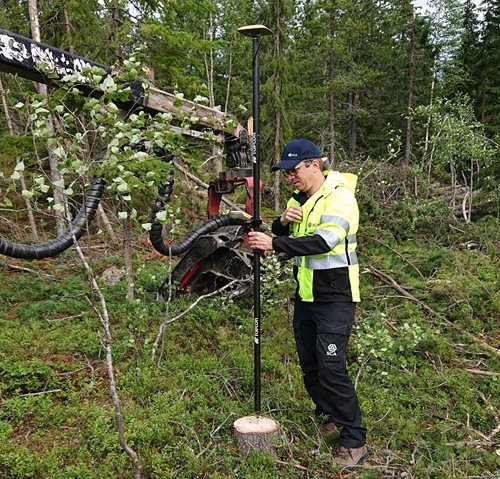
Reference measurements of the stumps' positions were made in the study. Photo: Skogforsk.
Machine operators are positive
The results from the study indicate that positioning and navigation are significantly improved with this prototype system compared to current technologies.

– An important part of the study was to let machine operators test the system. The improved information about travel direction, the position of the harvester relative to land boundaries, and more positively affect the operators' confidence and well-being. They don't have to be on high alert all the time. This trust is likely also beneficial for productivity and precision in execution, says Björn Hannrup, researcher at Skogsforsk who has led the study.
Breakthrough in the use of airborne laser scanning
The technology with improved positioning also opens up further research on various applications of airborne high-resolution laser data. When detailed data from airborne laser scanning and harvesters are combined, individual trees and their characteristics can be identified. The more data sources are matched, the larger the knowledge base becomes. Eventually, it becomes possible to obtain preliminary information about the characteristics of tree trunks based on a map of the tree crowns in the area before logging takes place.

– This is truly a breakthrough and completely changes the possibilities of using airborne laser scanning. By matching these two data sources, we can automatically calculate tree properties and obtain a detailed picture of the forest landscape," says Johan Holmgren, researcher at the Department of Forest Remote Sensing, SLU.
He sees that this can be useful in precision forestry, which takes better account of biodiversity, implements appropriate management measures, and can predict timber properties even before logging takes place.
– Now we are looking forward to these positioning systems becoming standard in new machines, says Johan.
Digital delineation - a near-term application
The study was conducted on SCA's land, and they see digital delineation as a near-term application, particularly related to various types of conservation areas. It is advantageous to know not only the location of the harvester but also the crane in relation to, for example, an archaeological site.

– In the short term, the greatest value lies in providing excellent support to the operators. It is when people feel that they truly benefit from new technology that it quickly gains traction and further development takes off. Being able to navigate forestry machines with high precision and coordinate production data forms the very foundation for autonomous forestry machines but is also important for reducing our environmental impact. This results in more efficient, considerate operations and improved forest management, says Magnus Bergman, Forest Technology Manager at SCA.
The image shows the map program that the machine operator sees. With higher accuracy, the forest machine is positioned within the circular ring. The arrow indicates the direction in which the crane is pointing. Image: SCA.

The yellow dots represent the results of the reference measurements, while the red dots show the positioning using the harvester's data. The average difference between them was half a meter. Image: Skogforsk
The image illustrates how detailed data from airborne laser scanning and harvesters are matched together. By combining these data sources, individual trees and their characteristics can be identified. "This is truly a breakthrough and completely changes the possibilities of using airborne laser scanning," says Johan Holmgren, SLU. Photo: Komatsu Forest.